Setting A Map
 Note that a compass actually points to magnetic north, and not true north and you will need to take this into account for precise bearing and orientation work. For the time being I will ignore this magnetic variation, and explain how to orientate the map roughly north. Even this will help in finding surrounding features on the map.
To set up the map, that is to ensure that the map is facing north, you will obviously need some sort of compass. I will assume we are using a typical 'Silva' type compass.
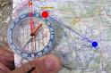
- Rotate the dial on the compass so that the N marker is aligned with the direction of travel arrow at the top of the map.
- Place the compass on the map. Line up the edge of the compass with a vertical (blue) grid line. (It is easier to line up the edge of a rectangular compass rather than try to align the direction of travel arrow with the grid line as this is partly obscured by the dial).
- Holding the compass and the map together (push down on the compass gently), rotate them as a whole so that the red arrow on the pointer (the piece that always faces north) aligns itself with the red arrow marked on the bottom of the dial itself (there will be some variation on this depending on what type of compass you have).
- As always, try to be as accurate as possible. Look directly down upon the two arrows to line them up. When this is done the map will now be facing north (ignoring magnetic variation, covered elsewhere). Try to keep the map in this position while you are using it. It is now ready for taking bearings and such like.
The process above is not complicated. It is a simple example of using a compass as described under bearings, except that we ensure the map also faces this direction.